
Carpenter Lake
The Cable Bay Shear Zone (“CBSZ”) is a crustal-scale, regional lithotectonic domain boundary, nearby and parallel to the Virgin River Shear Zone which separates the Rae and Hearne provinces of Archean and Proterozoic crystalline rocks. Major structures are a critical element to the formation of unconformity-type uranium deposits. The property covers the southern portion of the CBSZ where it crosses the southern margin of the Athabasca Basin.
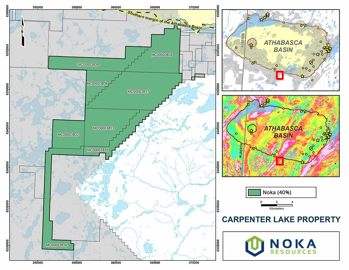
Location
- Southern margin of the Athabasca Basin in north-central Saskatchewan
Proximity to Uranium Discoveries, Deposits, Mills and Mines
- 95 km (approx.) west of the past-producing Key Lake uranium mine.
- 70 km (approx.) west of the active Key Lake Mill which is serviced by HWY 914.
- 45 km (approx.) southeast of the Centennial deposit on the Virgin River shear zone.
Property Description and Ownership
- 16,872 hectares (41,692 acres)
- 8 contiguous claims (mineral dispositions: MC00003832 to MC00003839)
- A 40% / 60% Joint Venture with ALX Uranium Inc. (TSX.V: ALX) (60% ALX – 40% NX)
Current Exploration
- Completed a FALCON® airborne gravity gradiometer survey: 340 line-km at 100-metre line spacing covering a grid area of approximately 10 x 4 km (see Alpha news release dated March 12, 2015).
Exploration
The uranium exploration potential of the Carpenter Lake property is underscored by the numerous uranium anomalies in historical lake sediment samples, reinforced further by airborne radiometric anomalies both along and west of the of the Cable Bay Shear Zone (CBSZ). The corridor of well-defined conductors along the CBSZ further highlights the potential for uranium mineralization along the regional structure, in particular where there is evidence for cross-cutting structures. The presence of conductive graphitic pelites as defined by airborne and ground electromagnetic surveys is confirmed by historic diamond drilling immediately north of the property.
In light of the vast improvement in the understanding of both the regional geology and tectonic history of northern Saskatchewan in the past 20 years, and the importance of structure in the formation of unconformity-type uranium deposits, the overall uranium potential of the Carpenter Lake property is vastly underexplored.
Exploration
2014
Summary of 2014 Summer Exploration at Carpenter Lake (see Alpha News Release dated October 28, 2014):
- An airborne time-domain electromagnetic and horizontal magnetic gradiometer survey (versatile time-domain EM) (see Alpha news release dated February 3, 2014).
- Airborne VTEM (versatile time-domain electromagnetic) and magnetic surveys in February: 1,892 line-km over a 10-by-20 km block at 100-metre line spacing.
- A detailed, low-altitude, airborne gamma spectrometer survey by Goldak Airborne Surveys.
- 3,931 line-km covering a 10-by-20 km block at 50-metre line spacing (see Alpha news release dated July 24 2014).
- Radon-in-water and radon-in-soil survey in March to April, 2014 (see Alpha news release dated May 21, 2014).
- 60 lake sediment samples collected during a three-week winter program.
- A boulder prospecting program was conducted in August 2014, to follow up targets defined from integrated airborne geophysical and ground geochemical anomalies.
- 71 rock samples collected during a three-week summer boulder prospecting program (see Alpha news release dated September 18, 2014).
- Detailed follow-up radon-in-soil and soil geochemical surveys to enhance targets established from previous surveys in April. Radon work was completed in September by RadonEx.
- 1,473 radon samples collected during a two-stage winter and summer program.
2015
- CGG Aviation (Australia) Pty Ltd. completed a FALCON® airborne gravity gradiometer gravity survey: 340 line-km flown at 100-metre line spacing covering a grid area of approximately 10 x 4 km (see Alpha news release dated March 12, 2015).
- The survey showed the magnetic signature is dominated by a sharp linear trend following the Cable Bay Shear Zone, but is narrower than the width of the entire zone. Closer examination shows that this magnetic response is broken and possibly slightly offset in places by cross-cutting structures. Image processing of the magnetic data helps bring out some less obvious details in the data.
- The FALCON® gravity gradiometry gD response shows a high in the area of the Cable Bay Shear Zone. In the central and northern end of the block, the gravity high extends to the southeast from the Cable Bay Shear Zone.
|
Work Type |
Year |
Company |
Work Report Details |
|
AIRBORNE |
1974 |
SMDC |
Helicopter gamma ray spectrometer survey |
|
GROUND |
1976 |
SMDC |
Lake sediment and water sampling |
|
AIRBORNE |
1977 |
SMDC |
Airborne E M (Input) and magnetic survey |
|
AIRBORNE |
1978 |
E & B EXPLORATIONS LTD |
Airborne E M, magnetic and radiometric survey |
|
GROUND |
1978 |
E & B EXPLORATIONS LTD |
Prospecting, lake water and sediment sampling |
|
GROUND |
1979 |
E & B EXPLORATIONS LTD |
Ground E M and magnetic survey |
|
GROUND |
1979 |
E & B EXPLORATIONS LTD |
Geological and geochemical (soil, radon) surveys |
|
DDH |
1979 |
E & B EXPLORATIONS LTD |
2 ddh records (#E-1-79, E-2-79) |
|
GROUND |
1980 |
SMDC |
Prospecting, geological mapping, vegetation, lake sediment, borehole water sampling, ground EM and magnetic survey |
|
DDH |
1980 |
E & B EXPLORATIONS LTD |
2 ddh records: gf, py & po (#E-80-1, E-80-2) |
|
AIRBORNE |
2007 |
STIKINE GOLD CORPORATION |
Geophysics: Airborne Magnetic and Electromagnetic GEOTEM (1969 line-km, Fugro Airborne Surveys Inc.) |